By Benjamin Barnett
Last month, the SFMTA and San Francisco Recreation and Parks Department released a survey seeking public feedback regarding five proposed roadway options for Twin Peaks Boulevard. San Franciscans responded to the survey, ranked support for each alternative and shared opinions about how the different options met their needs.
The Twin Peaks for All survey was open for almost three weeks and received more than 1,700 responses. This number reflects the high level of interest for this San Francisco park and its future access.
Survey Background

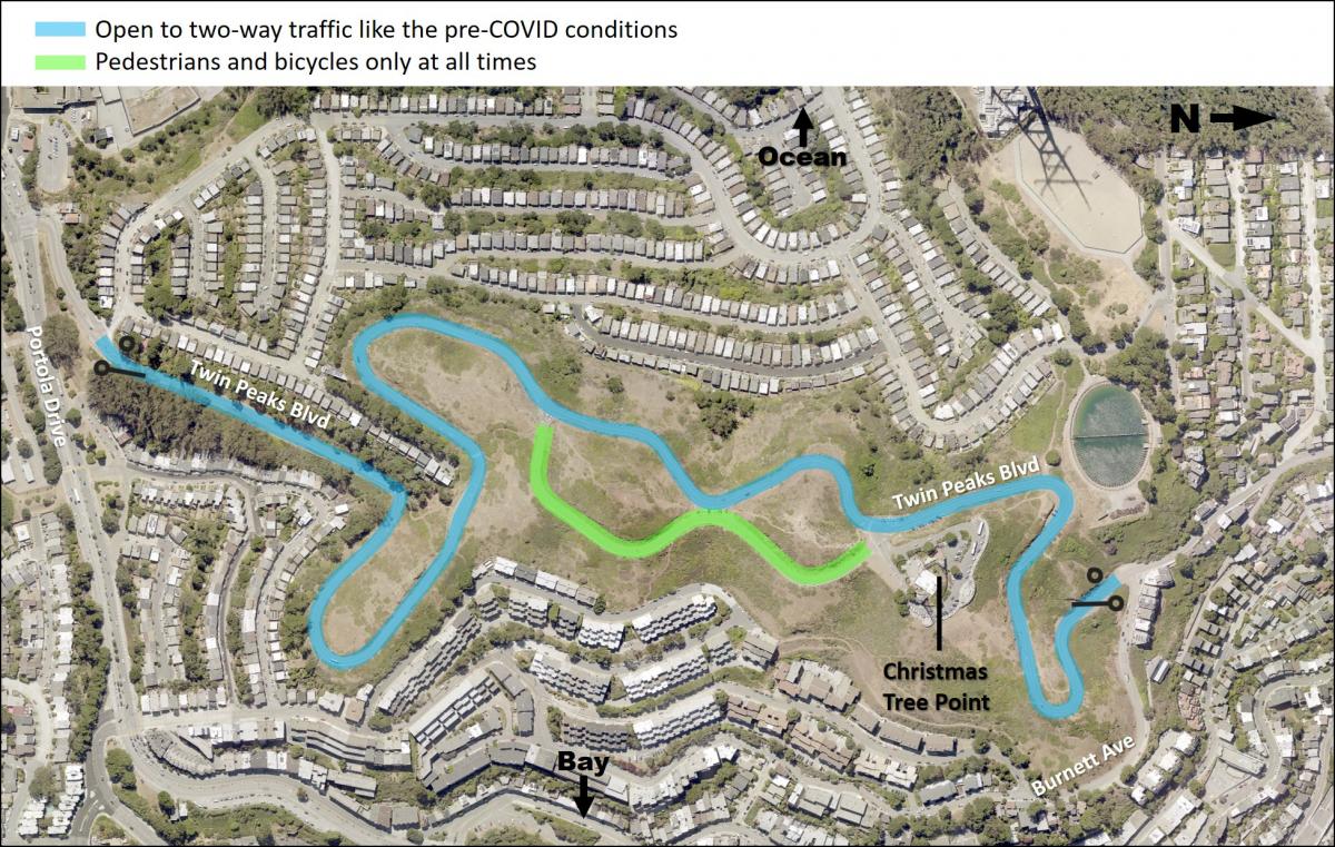
Conditions on Twin Peaks Boulevard between Portola Drive and Barnett Avenue before COVID street closures.
The Twin Peaks Boulevard gates were closed early in the pandemic to reduce crowding at the lookout point parking lot. The gates were closed on the north, at Burnett Avenue, and the south, at Portola Drive. Since then, Twin Peaks Park use by hikers, joggers and people on bicycles has increased significantly, with an average of more than 800-weekday visitors and more than 1,100-weekend visitors.
While the new park access configuration received support, there are also significant community concerns. Our goal with the new design proposals and survey is to find a solution that balances all the various needs of the community including people with disabilities, neighbors and everyone that enjoys this iconic park.
Survey Options:
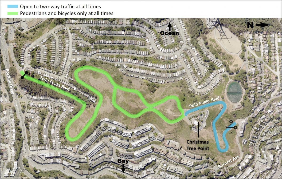
- Burnett Avenue - Burnett Avenue gate is open 24 hours, with parking and a vehicle turnaround available on Christmas Tree Point Road.
- Portola Drive - Continue keeping the Portola Avenue gate open, extending the hours from noon to midnight daily.
- One-Way Southbound - One-way, southbound vehicle traffic, from the north gate at Burnett Avenue to the south gate at Portola Drive. Reserve the northbound vehicle travel lane for people walking and bicycling.
- One-Way Northbound - One-way, northbound vehicle traffic, from the south gate at Portola Drive to the north gate at Burnett Avenue. Reserve the southbound vehicle travel lane for people walking and bicycling.
- Pre-COVID - Open both the north and south gates, as were conditions pre-pandemic. The east side of the figure eight is reserved for people walking and biking and the west side of the figure eight is reserved for two-way traffic.
Overview of Results:

Map representing the Burnett Avenue Option, the most preferred option according to the survey.
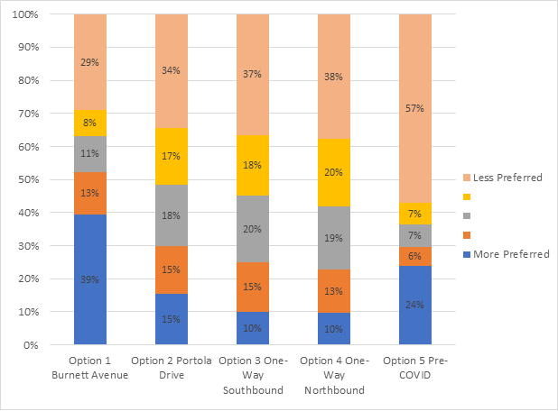
- The Burnett Avenue Option was most preferred with 52 percent of people ranking it highest in comparison to the other four options
- The Pre-COVID Option was the most divisive of the five options, it ranked as the second most preferred with 30 percent but also most respondents ranked it as less preferred with 64 percent of the vote.
- Mode of transportation to Twin Peaks was associated with responses, with visitors traveling by non-motor vehicular modes favoring the Burnett Avenue Option and visitors traveling by motor vehicular modes favoring the Pre-COVID Option
- Many respondents commented that they prefer some form of car-free space on Twin Peaks
- Survey respondents are concerned about sharing the road to the top of Twin Peaks with tour buses and motor vehicle traffic
- Crime, vandalism and litter are concerns associated with all options
What We Learned from You
Many people who filled out the survey are regular visitors to the area; almost 50 percent of the respondents typically visit Twin Peaks one or more times per week with another 27 percent of people who visit once per month. People who took the survey tend to reside near the park. The highest percentages of respondents came from zip codes immediately adjacent to the park and of the more than 1,700 responses, 50 respondents were from outside of San Francisco. In total, 52 percent ranked the Burnett Avenue option as their preferred choice. The next closest preference was the Pre-COVID option, with 30 percent.

Other data demonstrating Option 1 was the most preferred include:
- Trip frequency did not have an impact on preference, from the respondents stating that they rarely/never visit Twin Peaks to those visiting 1-4 times a week, Option 1 was preferred.
- Most respondents 64 years of age or younger preferred Option 1.Those 65 years of age or older preferred Option 5.
- Option 1 was the top preference across races/ethnicities.
More to Come
Access to Twin Peaks is important to San Franciscans and this was reflected by the large number of responses and the range of responses to the Twin Peaks for All survey. Responses reflected that both personal and property safety is important as is access to the beautifully scenic resource. For a much more detailed analysis of our survey data please visit our Survey Report.
SFMTA staff will continue to review the options, working with project stakeholders to develop a project that is feasible and meets the needs of the public based on the survey results. Staff will develop a final proposal to share with the community and present to the SFMTA Board of Directors for potential approval in the coming months. Twin Peaks is a beautiful and unique destination for San Francisco residents and visitors alike and everyone should have the opportunity to enjoy it. For more information or to sign up for an email update, visit our project page.
Published November 19, 2020 at 11:18PM
https://ift.tt/2IImjLb
Comments
Post a Comment