Just in Time for Bike Month: The Active Communities Plan Interactive Map!

Just in Time for Bike Month: The Active Communities Plan Interactive Map!
By Christopher Kidd

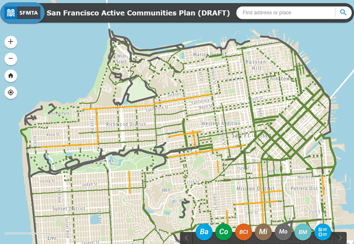
Image of a map with multiple lines seen. The legend on the bottom right includes about a half a dozen circles.

Image of the new Active Communities Plan (ACP ) interactive map 

As part of our ongoing public outreach about the Active Communities Plan, the SFMTA has created a new ACP interactive map.  The release of the map comes just a couple of weeks after we began collecting feedback through our new survey.  

The map shows conditions for biking, scooting and rolling across San Francisco, as well as multiple layers of analysis conducted by the Active Communities Plan team. It is meant to help users understand how different factors like comfort, safety and network quality influence whether people decide to use active transportation or not.  

We want users to have the opportunity to explore and compare data, reflect on how it compares to their experiences with active transportation and provide input about what kinds of solutions work best. 

The interactive map has six main layers to explore: 

  • Baseline Data – shows today’s active transportation network, our pipeline of approved projects and the location of every public bike rack in the city. 
  • Collision Analysis – shows the locations of bike and scooter collisions on the High Injury Network before the pandemic (2017-2019) and since the start of the pandemic (2020-2021), as well as the neighborhoods with the most unreported (unlinked) bike & scooter collisions. 
  • Comfort Analysis – shows the Bike Network Comfort Index (BCI), which categorizes perceived comfort or risk by people biking, scooting or rolling. This is only our first draft of the BCI – by taking our survey, you can help shape how the BCI is scored! 
  • Micromobility Analysis – shows what streets people ride most when using BayWheels e-bikes or scooters, which BayWheels stations get the most ridership and the service areas for our micromobility providers. 
  • Modeshare Analysis – shows data from the American Communities Survey: commute mode share by bicycle and the distribution of zero-car households. 
  • Bike and Micromobility Activity Analysis – combines our BayWheels e-bike trip data, scooter trip data and modeled bike and scooter trip data from Replica to estimate the volume of trip activity. You can view activity across the city, on the active transportation network or by network facility type. 

Once you’ve had a chance to explore our interactive maps, take our survey. The results will help us understand your needs and barriers to active transportation, as well as how safe or comfortable people feel using different types of streets. From there we can develop network, program and policy recommendations that directly reflect the needs and priorities of people across the city. Our survey runs through July 31st.  

The Active Communities Plan public engagement effort has reached more than 1,000 residents since January, and we have events scheduled through mid-June with more to come throughout the summer. Visit Active Communities Plan (SFMTA.com/ActiveCommunities) for our schedule, which is updated regularly. If you want us to attend your community meeting or event, contact ActiveCommunities@sfmta.com and let us know! 


Published May 03, 2023 at 02:19PM
https://ift.tt/DR7sZEQ

Comments

Popular posts from this blog

Reconnecting San Francisco Across Streets and Freeways

Reconnecting San Francisco Across Streets and Freeways By With limited space on San Francisco city streets, how can we ensure that current and future transportation options remain accessible and affordable to all? The San Francisco County Transportation Authority (SFCTA), the SFMTA and the San Francisco Planning Department are collaborating through ConnectSF in creating a template for an equitable, sustainable and effective future. Their Streets and Freeways Strategy examines approaches that support San Francisco’s Transit-First , Vision Zero , climate action , and equity goals .  The strategy complements the Transit Investment Strategy released in April 2021. SFMTA staff provided expertise in developing the strategy and is leading the Active Transportation component, exploring ways to build a connected network of bike and pedestrian routes across the city that make biking and walking safe and enjoyable. SFMTA staff from across the agency also developed strategies to ma

Have Feedback on the COVID-19 Muni Temporary Service Plan?

Have Feedback on the COVID-19 Muni Temporary Service Plan? By Shalon Rogers In March 2020, due to unprecedented constraints on resources brought on by the COVID-19 pandemic, the SFMTA had to make significant transit service reductions. As of January 2021, the agency has been able to restore service to a level where 91% of San Franciscans are within a quarter mile of a transit stop. This is reflected in the SFMTA’s current  COVID-19 Temporary Service Plan .   ' COVID-19 Temporary Service Plan Map The SFMTA is committed to ensuring that our programs and services are  compliant with Title VI of the Civil Rights Act of 1964  and therefore do not have a discriminatory impact based on race, color or national origin. As part of this work, we conducted a Title VI service equity analysis to evaluate the current COVID-19 Temporary Service Plan. The results of this analysis will be presented to the MTA Board of Directors on May 4. The public is invited to attend and provide comments on

Chinatown Connects to Muni Metro

Chinatown Connects to Muni Metro By Deanna Leo With the completion of Central Subway, customers will be able to ride the T Third Muni Metro all the way from Visitacion Valley to Chinatown. Starting November 19, when Muni Metro riders can first take Central Subway's special weekend service to Chinatown,  prepare to spend the day in Chinatown enjoying all its sights, sounds and flavors. There is so much to explore in the largest Chinatown outside Asia! Tourist attractions include the Dragon’s Gate, Old St. Mary’s Cathedral and Portsmouth Square, the site of San Francisco’s original customs house where today, members of the Chinese community spend the days singing or playing mahjong, a traditional and very popular tile-based game. Fans of Amy Tan’s novel, The Joy Luck Club, can meander the streets of Chinatown searching for the places where her story unfolds. On Wavery Place you can visit the First Baptist Church where the four mothers in the story meet to play mahjong. Muni M